On this day, 250 years ago, as the HMS Endeavour sailed up the east coast of Terra Australis Incognita, the captain of the ship, Lieutenant James Cook, wrote a significant comment in his journal. Cook was looking out across the sea to the land on which the sailors were yet to set foot—the land on which indigenous inhabitants had lived, slept, married, grown crops, caught fish, died and were buried, for centuries—for millennia. He described some people whom he saw on the land he was observing.
Cook had given a description of the land, itself, which he was able to observe from on board his ship. On 20 April, he wrote in his journal: “The weather being clear gave us an oppertunity to View the Country which had a very agreeable and promising Aspect the land is of moderate height diversified with hills, ridges, planes and Vallies with some few small lawns, but for the most part the whole was cover’d with wood, the hills and ridges rise with a gentle slope, they are not high neither are there many off them.”
[Cook’s journaling was strikingly absent of punctuation—we take it as it is, and make sense of it as we will.]
And he had also described some of the animal and bird life he was able to observe. On 18 April, he wrote, “Last night we saw a Port Egmont Hen and this morning two more, a Pintado bird several Albetrosses and black sheer-waters. The first of these birds are certain signs of the nearness of land.”
But on 23 April, he made comments specifically about the people that he was able to see on that land. He wrote, “after this we steerd along shore NNE having a gentle breeze at SW and were so near the Shore as to distinguish several people upon the Sea beach they appear’d to be of a very dark or black Colour but whether this was the real colour of their skins or the C[l]othes they might have on I know not.”
It would be almost another week before anyone from his ship actually set foot on the land that they had been sailing next to for some days. On Sunday 29 April, 1770, one of the sailors on board the HMS Endeavour, Isaac Smith, stepped off the ship and onto land beside what we now know as Botany Bay. Smith was the first British person to stand on the land of the east coast of the continent that we know now as Australia. (William Dampier, a British sailor of an earlier generation, had made landfall on the west of the continent back in 1688).
The relationships between the white explorers and the dark indigenous inhabitants would build and grow and become complex, over time—and be marked by numerous occasions of great tragedy, violence, misunderstanding, and sadness. For the moment, at this first sighting, Cook simply observes and describes.
We know the place where Smith and others made landfall as Kurnell, of Botany Bay, in New South Wales, on the continent Australia. What was it called by the indigenous inhabitants at the time when Smith, Cook, and other crew members from the HMS Endeavour, set foot there?
One hypothesis is that the name Kurnell derives from a Dharug word, variously transcribed as cunthal, kundle, or koondool, perhaps meaning “place of or where the wild carrot grows”. This was the suggestion made by W. Wentworth Bucknell, Honorary Secretary of the Royal Anthropological Society, in a letter published in the Sydney Morning Herald on 6 December 1912 (see https://trove.nla.gov.au/newspaper/article/15381124)
An alternative explanation is that it is a corruption of the surname of John Connell, who was granted land in the area in 1821. We cannot be certain about the precise of origin of this place’s name.
The issue of place names is a significant one. The indigenous inhabitants knew their country; their relationship with the land was, quite clearly, enmeshed with their culture, spirituality, lifestyle, and sense of identity. When white explorers sailed into their territory—and then, later on, when white settlers invaded and colonised the land, subdued and massacred the people, and established their own patterns of farming and living on the land of these indigenous inhabitants—they provided their own names, from their own culture.
Whilst many place names today can claim Aboriginal origins, still the vast majority of our places, suburbs, streets, and geographical features, bear names from the British (or Irish, or German, in some instances) who invaded, settled, and dominated the land. (The process of bestowing names goes by the term toponymy, from the two Greek terms topos, place, and onoma, name.)
Cook’s own journal provides numerous instances of his naming features that he observed from his ship, and bestowing British names on what he saw. On 19 April he called one location Point Hicks. This was the first land on mainland Australia which Cook sighted, and named.
It is said that Cook’s practice was to reward the first person to sight land with a gallon of rum, plus the distinction of having a place named after him. On this occasion, the prize fell to Lieutenant Zachary Hicks, who called out “Land ho” when he saw “land making high” in the hinterland of Australia’s south coast.
The traditional custodians of the land surrounding Point Hicks are the Bidhawal and Gunaikurnai peoples, who called the point Tolywiarar. That name is lost, now, in modern Australian toponymy.
The next day, 20 April, Cook’s journal records his comments about a place that he named Cape Howe, in honour of Admiral Earl Howe, the Treasurer of the British Navy at that time. I haven’t been able to find any reference to the indigenous name for this location. [My googling skills obviously leave something to be desired.]
On the following days, Cook noted and named many places along the south coast: Mount Dromedary and Cape Dromedary on 21 April, Batemans Bay and Pigeonhouse Mountain on 22 April, Cape St George, named for the day it was first sighted by Cook, on 23 April, and Long Nose Bay and Red Point on 25 April.
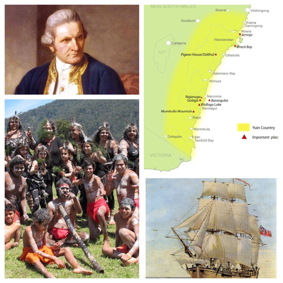
Gulaga is the place of ancestral origin within the culture and stories of the Yuin people, whose land encompasses the south coast of NSW, from Cape Howe to the Shoalhaven River. Gulaga is a large mountain inland from the current village of Tilba Tilba (between Narooma and Bermagui). In Yuin story-telling, holds particular significance for the Yuin people. The mountain and surrounding area is seen as a place of cultural origin. The mountain is regarded as a symbolic mother-figure providing the basis for the people’s spiritual identity.
In May 2006 the Gulaga National Park, incorporating the former Wallaga Lake National Park, was handed back to its traditional Aboriginal owners, the Yuin people, in a historic agreement signed by the NSW Government and the Yuin people. Gulaga, of course, was the mountain which Cook named as Mount Dromedary, as its figure reminded him of the hump of a camel.
In his journal for 22 April, Cook wrote: “At 6 o’clock we were abreast of a pretty high mountain laying near the shore which on account of its figure I named Mount Dromedary Latde 36°..18′ & Longde 209°..55′ Wt / The shore under the foot of this Mountain forms a point which I have named Cape Dromedary over which is a peaked hillick.“
The traditional custodians of the land surrounding Batemans Bay are the Walbunja clan of the Yuin people. The traditional language spoken by the Walbunja people is Dhurga. A number of sites in the region are considered culturally significant to the Aboriginal peoples.
On 22 April 1770, Cook first sighted this bay; he immediately gave it a British name. Cook gave no reason for the name, which may commemorate either Nathaniel Bateman, the captain of HMS Northumberland when Cook was serving as her master (1760-62), or John Bateman, 2nd Viscount Bateman, a former Lord Commissioner of the Admiralty in the 1750s.
Further south, there are a number of locations which are considered to be significant sites for the Yuin people: Umbarra (Merriman Island), Barungba (Montague Island), and Dithol (Pigeon House Mountain).
Pigeonhouse Mountain was first seen by Cook at 7 a.m. on 21 April, 1770. Cook later noted in his journal, “The land near the Sea coast still continues of a moderate hieght forming alternatly rocky points and Sandy beaches, but inland between Mount Dromedary and the Pigeon house are several pretty high Mountains two only of which we saw but what were coverd with trees and these lay inland behind near to the Pigeon house and are remarkably flat atop with steep rocky clifts all round them as far as we could see – the trees in this Country hath all the appearence of being stout and lofty.”
The Aboriginal name for the mountain is Didthul, Didhol, or Dithol, which means “woman’s breast”, on account of the distinctive shape of the mountain.
Cape St George was named for the day it was discovered—St George being the patron saint of England whose saints day is 23 April. On 24 April his journal includes the comments, “A point of land which I named Cape St George we having discover’d it on that Saints day, bore West distant 19 Miles and the Pigeon house So 75° West, the Latitude and Longitude of which I found to be 35°..19′ S and 209° 42′ West.” I have not been able to find any reference to the indigenous name for the area.
The next day, Cook recorded, “About 2 leagues to the northward of Cape St George the Shore seems to form a bay which appeard to be shelterd from the NE winds but as we had the wind it was not in my power to look into it… The north point of this bay on account of its figure I named Long Nose, Latitude 35 degrees 4 minutes S.3.” Long Nose Bay is obviously named for its appearance. Again, I can’t see any indication of what the indigenous name for this place was.
There are other names in the localities which Cook was observing, which today bear names derived from the local indigenous language. In what follows, I am drawing from the notes provided by the NSW Government Geographic Names Board (see https://www.gnb.nsw.gov.au/place_naming/place_name_search) as well as various local history or tourism sites, which provide insight into local understandings of the origins of the names of these places.
The list below traces indigenous names in existence today from Batemans Bay south to Eden, retracing in reverse the path of Cook’s 1770 voyage. (I have focussed on this region because it is the area of the South Coast which falls within the Presbytery in which I am currently ministering, the Canberra Region Presbytery.)
Eurobodalla is said to be named from an Aboriginal word meaning “small haven for boats” or “land between waters”. Several meanings have been put forward for the name Bodalla, including “Boat Alley”, “tossing a child up in the arms”, “haven for boats” and “several waters”.
The name Moruya is said to be derived from an Aboriginal word, (phonetically) mherroyah, meaning “home of the black swan”. Black swans can still be seen in the lakes and rivers around Moruya, and the black swan is used locally as an emblem.
In Narooma, the story is that this name comes from an Aboriginal word for ‘clear, blue water’. It was to become the name of the area after Francis Hunt sold his property known as “Wagonga” in 1839 to Thomas Forster who renamed it Noorooma. Yuin Elder Gubbo Ted Thomas advises, however, that Noorawa is the Yuin word for the bubble yellow seaweed that grows in the inlet.
Bermagui is derived from a word in the Dyirringany language (a language group within the Yuin nation), permageua, possibly meaning ‘canoe with paddles’. Tilba Tilba is the original name of the district, and is said to be a word from Tharwa (another language group within the Yuin nation) meaning “many waters”. Cobargo may have originated from a Yuin word, cubago, which some sources claim was used to describe the nearby mountain, Gulaga. Quaama is a Yuin word meaning “shallow waters”.
One claim is that the name Bega is derived from a Yuin word meaning “big camping ground”. Another claim is that it is a corruption of the word bika, meaning “beautiful”. Just outside Bega, there is a village called Tarraganda. The story locally is that a man named Joshua Higgs claims to be the one who named Tarraganda. Many years ago, Higgs told W F Braine of the Bega Gazette that “we asked the blacks what they called the spot and, in their quick way, they said what I took to be Tarraganda”. It is said to mean “a string of waterholes”.
There is considerable debate about the Aboriginal (presumably Yuin) meaning of Merimbula. Some sources claim it means “big snake”. Others claim the word means “place of two waters or lakes”. The name Pambula is derived from a Dharwa word panboola, meaning “twin waters”.
It is good that we have many names that honour the names given to these places by the indigenous peoples, who for so long have cared for these lands. It is also good that we can delve below the British names in at least some locations, to recover and recall the indigenous names for these places.
There’s lots of detail about Cook, the Endeavour, and his voyages, at https://www.captaincooksociety.com/home
For information about Yuin country, see https://livingknowledge.anu.edu.au/learningsites/kooricoast/05_map.htm
https://aiatsis.gov.au/exhibitions/south-coast-new-south-wales
https://earthtreasurevase.org/2018/10/south-east-coast-yuin-country-australia/
http://bermaguihistoricalsociety.org.au/djiringanj-yuin-nation/
For more thoughts on indigenous history, see my previous blogs at:
On the Day of Mourning, https://johntsquires.wordpress.com/2019/01/16/the-profound-effect-of-invasion-and-colonisations/
On Arthur Philip, https://johntsquires.wordpress.com/2019/01/18/endeavour-by-every-possible-means-to-conciliate-their-affections/
On James Cook, https://johntsquires.wordpress.com/2019/01/20/we-never-saw-one-inch-of-cultivated-land-in-the-whole-country/
On William Dampier, https://johntsquires.wordpress.com/2019/01/22/they-stood-like-statues-without-motion-but-grinnd-like-so-many-monkies/
On recent books, https://johntsquires.wordpress.com/2019/01/24/resembling-the-park-lands-of-a-gentlemans-residence-in-england/
On Cook and Flinders, https://johntsquires.com/2019/01/25/on-remembering-cook-and-flinders-and-trim-bungaree-and-yemmerrawanne/

One thought on ““They appear’d to be of a very dark or black colour”. Cook, HMS Endeavour, and the Yuin people and country.”